‘favelas 4D’ by MIT senseable city lab uses 3D laser scanning technology to analyze the morphology of rocinha, the largest favela in rio de janeiro. the project employs light detection and ranging (LiDAR) remote sensing to map the brazilian informal settlement, and deliver actionable urban planning insights based on the findings. favelas take shape spontaneously and competitively in dense, multilayered forms, resulting in a complex urban morphology with no underlying plan.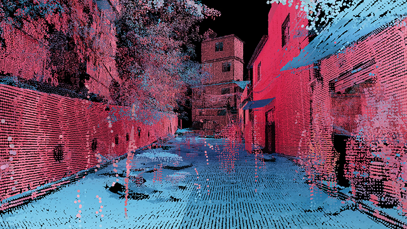
the LiDAR scans analyzed for ‘favelas 4D’ comprise over a billion points in total
all images courtesy of MIT senseable city lab
using detailed point cloud data from LiDAR scans taken at street level in the favela, researchers at MIT senseable city lab are able to define the morphological variations of this complex environment at very high resolution. LiDAR utilizes a laser pulse to measure distances and map points to locations in space in order to create a dataset that defines a 3D environment. the advantage of LiDAR as a research medium is its precise representation of the built environment. it reveals patterns in the unregulated construction of the favela, illuminating the tendencies of urban development and revealing actionable insights that can inform interventions and policies to improve safety.
 researchers created a data analysis method to capture morphological variation from LiDAR, using measurements like building dimensions and elevation
favelas struggle with property trading due to the lack of land tenure, landslide risks of the unstable terrain they occupy, and water and air quality caused by the limited infrastructure and services that reach them. all of these issues are implicated in the shape of the built environment.
‘despite their challenging circumstances, favela residents have developed ingenious and responsive ways to build their own urban systems. this bottom-up planning process and the complex architectural forms it produces can challenge the standard way of designing cities,’ observes carlo ratti, MIT senseable city lab director and professor of the practice.
street detection, accomplished using point verticality, is key to the ‘favelas 4D’ analysis, which focuses on comparing morphology within and among different streets in the favela
‘favelas 4D’ examines the urban form of a quantitative perspective, using data analysis techniques to describe and map the morphological dynamics at work in rocinha. the analysis operates at two resolutions, including a global analysis focused on comparing different streets of the favela to others, and a local analysis unpacking the variation of morphology within streets. five morphological factors are considered: street width, street elevation, the density of façades, variance in façade height, and street canyon (the ratio of façade height to street width).
with the extreme detail of LiDAR and the embedded perspective of street-level scanning, ‘favelas 4D’ conducts quantitative analysis from an immersive view
using the results of the analysis, it is possible to map morphological information at a resolution of 0.5 meters directly onto the favela’s plan. these maps of the two sample scanning areas reveal morphological features like pinching and widening of streets and clusters of tall buildings. they show the variable morphology of the scanning area used in this research, and they offer a glimpse of the type of valuable information that will be available when the whole favela is scanned.
‘the findings could also be used to develop planning strategies that make the formal city more inclusive to informal settlements, or to spark research into alternative ways of building that make urban environments more accommodating and affordable to their growing populations,’ explains washington fajardo, the city planning commissioner for rio de janeiro and collaborator on the project.

the results of the analysis can be expressed as maps of the favela tracing morphological metrics (street width, street elevation, street canyon, and facade height) at a resolution of 0.5 meters
this analysis contributes to the improvement of favela conditions and also raises questions about development practices and methods of city-building overall. as informal settlements around the world continue to grow, researchers and planners must integrate them with visions of the global urban future, both by learning from their unique development patterns and by improving their access to the benefits of formalized urbanism. ‘favelas 4D’ contributes to this goal by mobilizing the unique capabilities of LiDAR data and the revelations of quantitative analysis, offering an example of how 3D morphological analysis can help us understand and shape the cities of tomorrow.
project info:
name: favelas 4D
designer: MIT senseable city lab
director: carlo ratti
project and design manager: fábio duarte
project lead, research: arianna salazar miranda
visualization, research: guangyu du
research: claire gorman
collaborator: washington fajardo (project advisor)
designboom has received this project from our ‘DIY submissions‘ feature, where we welcome our readers to submit their own work for publication. see more project submissions from our readers here.
edited by: christina petridou | designboom
MIT media lab (56)
 May 26, 2024
 Sep 21, 2023
 Aug 11, 2023
 Aug 03, 2023
 Aug 01, 2023
MIT news (75)
 Apr 02, 2024
 Jan 26, 2024
 Jan 12, 2024 Aug 03, 2023
PRODUCT LIBRARY
 Jul 22, 2024
 Apr 22, 2024
 Mar 21, 2024
 Mar 13, 2024